Image from http://idav.ucdavis.edu/~okreylos/ResDev/SARndbox/
|
|
I am constructing this page as a reference page for teachers (or anyone else) who is interested in constructing a fascinating new toy, combining innovative technology with a good old fashioned sand pit.
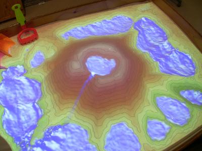
The augmented reality (AR) sandbox allows users to create topography models by shaping real sand, which is then augmented in real time by an elevation color map, topographic contour lines, and simulated water. The system teaches geographic, geologic, and hydrologic concepts such as how to read a topography map, the meaning of contour lines, watersheds, catchment areas, levees,
I can't wait to get this project underway and will be adding our progress to the EDHS STEM Lab blog. I will link all resources I use in the project and take no credit for the design.
If I fail to credit your work correctly please let me know so I can rectify it
I have had a quick play with the AR sandbox built by the amazing team of educators at the Rostrata STEM-Lab and can see so much potential for introducing this kind of technology as a learning tool for our school.
|
|
|
The resulting augmented reality (AR) sandbox allows users to create topography models by shaping real sand, which is then augmented in real time by an elevation color map, topographic contour lines, and simulated water. The system teaches geographic, geologic, and hydrologic concepts such as how to read a topography map, the meaning of contour lines, watersheds, catchment areas, levees, etc.